Is it possible to contour a terrain in Bryce?
 Jamahoney
Posts: 1,791
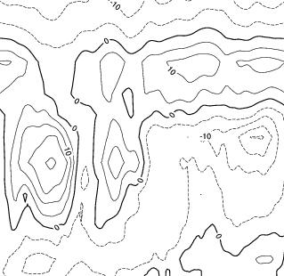
Just a query: I'm looking to contour a terrain that I have - from a bumpmap (heightmap, DEM etc.,), and wondering if it is possible?
To clarify, say, you create a terrain in Bryce (with all its humps and bumps, undulations...etc.,), but instead of wanting the full terrain shown, you only want it to show contour lines for the terrain (see image).
I think I saw some line art technique (image or tut) here in the Forum some time back, but can't for the life of me find it. Any suggestions greatly appreciated.
Jay


contour.jpg
319 x 310 - 71K


Comments
@Jamahoney - I haven't tried exactly this, only the reverse: creating a terrain out of isohypses. As a start, I'd suggest to bring the resolution of the terrain down. In the terrain editor, move the mouse over Posterize, hold down the left hand mouse key and move the mouse left and right. Then export the terrain as image.
To create the contour lines, you'll need a graphics application. Or you can use the methods shown in our Stylised Rendering product and do CEL shading right in Bryce. Whether this will give you the desired effect, I cannot say so I'm not suggesting that you lay out money which may prove to have been a waste. But do look at the promo images to see what can be done.
Jay, did you receive the PM I sent you?
Horo...that sounds vey interesting, and a way out of my predicament, so will give it a try. Btw, apologies also for not getting back to you re: the Bump Map, which I've now just downloaded...so thanks a bunch for that. Stupidly, I forgot to check my DAZ email account, which I only use occassionally, and thought it might come through my normal email server where I get the regular DAZ emails and offers...etc. Haven't opened it up the zip file yet, as it's just finished downloading while writing, however, I'm sure it will prove very useful in future animations.
Chohole (Pam)...Just replied back to your PM in the DAZ email account, so you should have the necessary details concerning the prize stuff. Again, as above with Horo, I didn't think of to check out the DAZ email account, apologies to you also.
Jay
Horo...just did a Google on the Stylised Rendering product in DAZ (didn’t know originally what to look for) and also David’s vid on the whole process, too). That may be the place I original came across the initial inquiry for above. Looks super for the many effects the product can achieve – bet there are architects, graphic designers who would well benefit from it.
Tried your above technique (Posterize..etc.,), and it works quite nice to an extent (see below), but some detail is lost. However, it does give leeway to play around with the original terrain now, and see where it goes from there.
Again, thanks for your help.
Jay
You are more then welcome, Jay. Glad I could give you a start.
Horo...that EarthBump is excellent also, and suits Bryce great (image below shows a low-rez, coloured topographic mat overlaid on the bump - Africa and South America/Ant-Arctic views...etc.,).
An animation of said world rotating would look vey cool indeed using this bump, I'd say, so very happy to have this for future works.
Cheers, again
Jay
You did this with the map I put up for you? If yes, you did much more with it than I. It was well worth to make it available to you.
BumpMap really is the kiddy. Tried adding in an atmosphere in this terrain/vegetation ovelay – not so realistic, I know. Could take it into Photoshop (or, my “free out-dated copy of Photoshop Elements 2.0” as I like to call it) and do the necessaries, but keeping it Bryce-ic to true form. It looks like Florida, however, is having a nice day...:)
Jay
Yee-ees.... Frankly, I'm a little skeptical that a rotating Earth WOULD look cool in Bryce, given that bump maps are the key source of dithering/shimmer in animation renders. (work-arounds to reduce shimmer normally result in prohibitively long render times.)
Good point...I'll presume, given your Bryce animation knowledge (experience?). Most ani's., of planets from afar I've used have simply been of a 'flat', mat overlay of said on a Bryce sphere, but never a bump-map, as the camera 'zooms in' (or flys-by). Will note it, however, if ever above approach is used in the future - one to be aware of, for sure.
Jay
Hey Jama,
Shimmer 'really depends'. Meaning, shimmer occurs when image render definition starts strobing with pixel definition. So if the object is really close to the camera, and the bump map is fairly thick and large, you won't notice much shimmer. If you're far away from the object (or the bump definition is small), You're likely to get more shimmer.
Best bet is to not use bump on planet shots, because really, you can't SEE bump or shadows when you're any distance from a planet: you just see shadows. There's no perceived depth. So you're better off with a map that has hard shadows painted on it, then cut to a close-up scene with actual, modelled terrains (masked by an artful close-field swoop of a cloud, of course :)